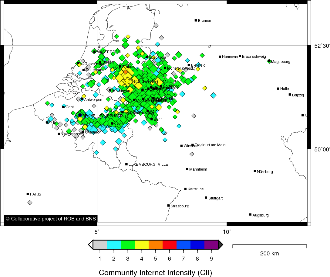
GOCH (DE) - 2011-09-08 19:02:50
- Magnitude 4.3
Last update : 2016-11-24 12:12:39 Belgian time
Main parameters
| Date and time |
2011-09-08 19:02:50 UTC
2011-09-08 21:02:50 Belgian time |
| Type | Earthquake |
| Magnitude | ML 4.3 |
| Maximal intensity | IV |
| Region | GOCH (DE) |
| Epicentral coordinates | 51.668° N, 6.162° E Uncertainty ± 0.9 km |
| Depth of hypocenter | 10.0 ± 1.2 km |
Data source : ROB (Royal Observatory of Belgium)
Location map
Quake measurements
Measurements by the Belgian seismic network
| Station | Epicentral distance (km) |
P-Wave arrival (hh:mm:ss.ss) | S-Wave arrival (hh:mm:ss.ss) | Maximal ground displacement (nm) |
|
|---|---|---|---|---|---|
| Code | Place | ||||
| HRK | HERKENBOSCH | 53 | 19:02:59.28 | 19:03:06.49 | 8277.6 |
| OPT | OPITTER | 72 | 19:03:03.11 | 19:03:12.40 | 5056 |
| MOLT | MOL | 90 | 19:03:05.84 | 19:03:17.96 | - |
| MOLS | MOL | 90 | 19:03:06.02 | 19:03:18.37 | - |
| DSLS | DESSEL | 90 | 19:03:06.04 | 19:03:17.49 | - |
| EBN | EBEN-EMAEL | 103 | 19:03:07.42 | 19:03:19.78 | 13171.8 |
| MEMS | MEMBACH | 118 | 19:03:09.60 | 19:03:23.67 | 7414.5 |
| LCH | LA CHARTREUSE | 121 | 19:03:10.05 | 19:03:24.75 | 5391.6 |
| STI | SART TILMAN | 128 | 19:03:11.10 | - | - |
| CLA | CLAVIER | 151 | 19:03:13.98 | 19:03:30.83 | 2954.6 |
| UCCS | UCCLE | 159 | 19:03:15.14 | - | - |
| GES | GESVES | 162 | 19:03:15.29 | 19:03:33.22 | 2734.9 |
| CSE | COURT-SAINT-ETIENNE | 162 | 19:03:15.42 | 19:03:33.30 | 7113.4 |
| KLB | KALBORN | 175 | 19:03:17.11 | 19:03:36.66 | 2252.4 |
| RCH | ROCHEFORT | 181 | 19:03:17.52 | 19:03:35.13 | 1973.5 |
| RQR | RONQUIÈRES | 180 | 19:03:17.58 | - | - |
| MRD | MAREDSOUS | 181 | 19:03:17.80 | - | - |
| SKQ | STEENKERQUE | 184 | 19:03:17.97 | - | - |
| SNF | SENEFFE | 184 | 19:03:18.34 | - | - |
| LES | LESSINES | 194 | 19:03:19.37 | - | - |
| BRQ | BRACQUEGNIES | 194 | 19:03:19.48 | - | - |
| VIA | VIANDEN | 193 | 19:03:19.53 | 19:03:40.48 | 1465 |
| DOU | DOURBES | 207 | 19:03:21.08 | - | - |
| BOU | BOUGNIES | 211 | 19:03:22.11 | - | - |
| WLF | WALFERDANGE | 223 | 19:03:23.01 | - | - |
| OSTB | OOSTENDE | 229 | 19:03:23.02 | 19:03:47.74 | - |
Measurements by the German seismic network of Bensberg (University of Cologne)
| Station | Epicentral distance (km) |
P-Wave arrival (hh:mm:ss.ss) | S-Wave arrival (hh:mm:ss.ss) | Maximal ground displacement (nm) |
|
|---|---|---|---|---|---|
| Code | Place | ||||
| ROD | DALHEIM RÖDGEN | 58 | 19:03:00.23 | - | - |
| LAU | LAUPENDAHL | 65 | 19:03:01.20 | - | - |
| BOR | BORSCHEMICH | 68 | 19:03:02.09 | - | - |
| MIL | MILLENDORF | 80 | 19:03:04.16 | - | - |
| HMB | HAMBACH | 84 | 19:03:04.77 | - | - |
| JUE | JÜLICH | 86 | 19:03:05.00 | - | - |
| BER | BERGHEIM (ORG) | 86 | 19:03:05.14 | - | - |
| ROE | ROETSCHBERG | 88 | 19:03:05.56 | - | - |
| BNS | BENSBERG | 105 | 19:03:08.42 | 19:03:20.68 | - |
| DRE | DREILÄGERBACH | 112 | 19:03:08.90 | - | - |
| KLL | KALLTALSPERRE | 114 | 19:03:09.18 | - | - |
| HOB | HOHBUSCH | 112 | 19:03:09.29 | - | - |
| STB | STEINBACHTALSPERRE | 129 | 19:03:11.41 | 19:03:26.51 | - |
| HIL | HILLESHEIM | 157 | 19:03:15.08 | - | - |
| KOE | KÖPPEL | 177 | 19:03:17.88 | - | - |
| BGG | BURG ELTZ | 182 | 19:03:17.95 | - | - |
Measurements by the Dutch seismic network of KNMI (Royal Netherlands Meteorological Institute)
| Station | Epicentral distance (km) |
P-Wave arrival (hh:mm:ss.ss) | S-Wave arrival (hh:mm:ss.ss) | Maximal ground displacement (nm) |
|
|---|---|---|---|---|---|
| Code | Place | ||||
| WTSB | WINTERSWIJK NEW | 55 | 19:02:59.95 | - | - |
| HGN | HEIMANSGROEVE | 102 | 19:03:07.42 | - | - |
| WIT | WITTEVEEN | 132 | 19:03:12.02 | - | - |
Data policy
Please read on this notice to learn more about our data policy.

